The castle is built on the spacious top of a tall hillock m. 357 ses.l.m. and covered by a wooded mantle. The urban implant is formed from a nucleus, delimited by the ancient surrounded building, and from some residences risen to the outside. The suburb introduces an articulated building aggregation in blockades prepared shutly enough to the sides of the principal road axle, directed approximately by west east, that races in match of the ridge and it is crossed with an axle secondary meridian.
The buildings are to one or two floors over the ground floor, rather non-constant in the release of the vain ones and the openings. An element, still today present, of urban and architectural characterization is the construction material, constituted at sight by stone to non-constant pezzatura and from bricks; recent operations have interested some has you dress again of a layer of plaster that you/he/she has altered partly the native character of it. The hedgings, in tiles, they are primarily articulated to 2 raining, but the roofs still store him to an alone piovente, visible in a representation of Sorbolongo in the'600. The routes are brief, narrow, exclusively to pedestrian use, in some good buys marked by gateways covered from vain that climb over the tracts. The road layout that develops him in light pendency from the two principal aces is joined on the route that coasts along the inside of the boundaries and that it contributes to underline the building compactness of the suburb; the light gradients are, in some cases, overcome by brief staircases.
Among the architectural elements of great relief they are the boundaries, whose origin is to make to go up again a first years of the XIII century, when Pope Onorio III enjoined to every place marchigiana to encircle him of fortifications because of the continuous wars. They still appear to a large extent well you store, thanks also to jobs of funding and restructuring immediately played in the years precedents the second world conflict. The ancient one, only, hands of the suburb and the line of boundaries to it adjoining I/you/they have been demolished instead for making place to the two roads of logging to the inhabited area. Nothing has remained of the tower or "rampart", that leaned out in prominent way on the valley of the Metauro, surely demolished and eliminated with party of the wall. The parish church is situated in the most elevated pixel to the western extremity of the suburb behind the surrounded building. A representation of Sorbolongo contained in a 1665 cadaster, the 1835 pontifical cadastral survey and that of the 1883 Italy Kingdom they allow to make interesting comparisons with the actual urbanistic situation and to know therefore the evolution of the nucleus within over three centuries
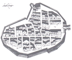
 antica pianta del castello di sorbolongo (Catasto-1665)
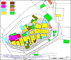
The comparison among the images highlights the substantial maintenance of the urban lay-out and the building patrimony kind of that located along the longitudinal road axle. In the nineteenth-century planimetries and in that actual they don't appear, instead, some constructions, existing in the '600, overlooking the church and the northern sector of the boundaries; to their place today, as in last century, I am the plaza of the parish and other two breadths, once turned to Market. Nevertheless, in the party of inhabited area more stretched out toward the ancient rampart, some buildings actually remain to the times of the pontifical catastazione for then to disappear in that following of 1883 (fig. 2). In the '600 the only existing plaza was that before the gate of logging, on which the economic life converged and social of the suburb. In fact the building of the Community and the Captain's habitancy, the parish priest house, the oven and the shop of the bread had localized. Today the use of the buildings that you/they lean out on the piazzetta is changed; that of the Captain became actually town center to the 1928. In the suburb they also had his/her own habitancy some notable families of whom I/you/they are suitable the residences in the seventeenth-century plant. It is not you suitable instead her "domus hospitalis", risen of hospice for wandering that had to practice also functions of public Aid to the needy ones and the sick; but with all probability the building in matter was situated near the plaza of the Commune.
|
|
Besides, an element of important comparison is constituted by the boundaries, entire in the '600 and today lacking of the portal and relative posting of watch (besides still existing at the end of the eight hundred), of the rampart and of an inclusive line among these colons, where you/he/she has found place a road of logging. A situation almost similar to that of Six hundred finds again him in the nineteenth-century planimetries, except a practiced gateway in the southern line, perhaps in concurrence of less preserved parties. In the pontifical cadaster they are suitable some Areas ortive, partly reabsorbed from builds him following, but of which remain still some edges some turned into gardens. With amazing precision they coincide in the various images tracts, alleys, covered gateways; the only exception is constituted by the western extremity of the longitudinal road axle that, open toward the surrounded building in the cadastral representations seventeenth-century and pontifical, in the cadaster of the Kingdom of Italy, as currently you/he/she is obstructed by a body of factory that has united the church to an adjacent building, turning him/it into the parish house. Nearly unchanged also the route that he unties inside the boundaries on which the whole urban road layout is joined. The tract, that has exclusive function of panoramic balcony today, anciently constituted a characteristic main point in how much, in case of war, it allowed easy moves of militias along the fortification. To testimony of the ancient ranking of Commune the old town palazzetto still stays with the clock (restored and restructured) and the headstone devoted to the fallen ones of the first world war.
In the territory of his/her appurtenance two Benedictine monasteries were found, that of Saint Giustina, demolished for a long time, and that of St. Maurice, both certificates since the year Thousand.
